Log in
All resources
Create a design
940 Free Artworks of Maps Of Landes
eran laor cartographic collection
bibliothèque nationale de france
1858 van de velde maps of palestine and jerusalem
africa in the 1890s
maps of africa
old maps of the holy land
guillaume sanson
maps of the lands of the house of orange
maps from the earth and its inhabitants, vol. xiii
maps of the land of valkenburg
maps of carmel valley, california
james meadows
maps of hooge zwaluwe
maps of lage zwaluwe
maps of antwerp by braun & hogenberg
maps of antwerp city walls
peeps at many lands: china
old maps of china
peeps at many lands: japan
old maps of japan
maps from the earth and its inhabitants, vol. xiii
africa in the 1890s
maps from the earth and its inhabitants, vol. xii
africa in the 1890s
maps from the earth and its inhabitants, vol. xiii
maps of africa
r. hausermann, carte de la terre sainte, 1914
eran laor cartographic collection
r. hausermann, carte de la terre sainte, 1914
eran laor cartographic collection
r. hausermann, carte de la terre sainte, 1914
eran laor cartographic collection
old maps of the united states
copper engravings
manual of the corporation of the city of new york (1856)
george hayward
old maps of st. augustine, florida
john white (colonist and artist)
maps of the battle of shiloh
memoirs of henry villard
maps of the land of valkenburg
guillaume sanson
maps of the land of valkenburg
guillaume sanson
situs terrae promissionis by christian van adrichom
eran laor cartographic collection
maps of the history of palestine
1880s maps of palestine
tower of babel in engravings
maps by nicolaes visscher i
eran laor cartographic collection
philippe de la rué
maps of the history of sweden
1386 in sweden
eran laor cartographic collection
william hole (engraver)
eran laor cartographic collection
william hughes (geographer)
eran laor cartographic collection
isaak tirion
charles william meredith van de velde
eran laor cartographic collection
old maps of the sinai peninsula
1870s maps of palestine
17th-century maps of the mediterranean sea
guillaume sanson
1858 van de velde maps of palestine and jerusalem
1850s maps of jerusalem
18th-century maps of antarctica
1741 maps
maps of krimpenerwaard
atlas novus (blaeu)
maps of the land of oz
1914 maps
maps of paris from the princeton university library
1750s maps of paris
maps from the earth and its inhabitants, vol. xii
africa in the 1890s
maps from the earth and its inhabitants, vol. xiii
africa in the 1890s
maps from the earth and its inhabitants, vol. xiii
africa in the 1890s
considérations géographiques et physiques sur les nouvelles découvertes au nord de la grande mer
hokkaido in art
maps of the land of valkenburg
guillaume sanson
maps of the land of valkenburg
guillaume sanson
considérations géographiques et physiques sur les nouvelles découvertes au nord de la grande mer
1750s maps of the russian empire
plans of central cemetery in sanok
maps of sanok
maps of paris from the princeton university library
18th-century maps of paris
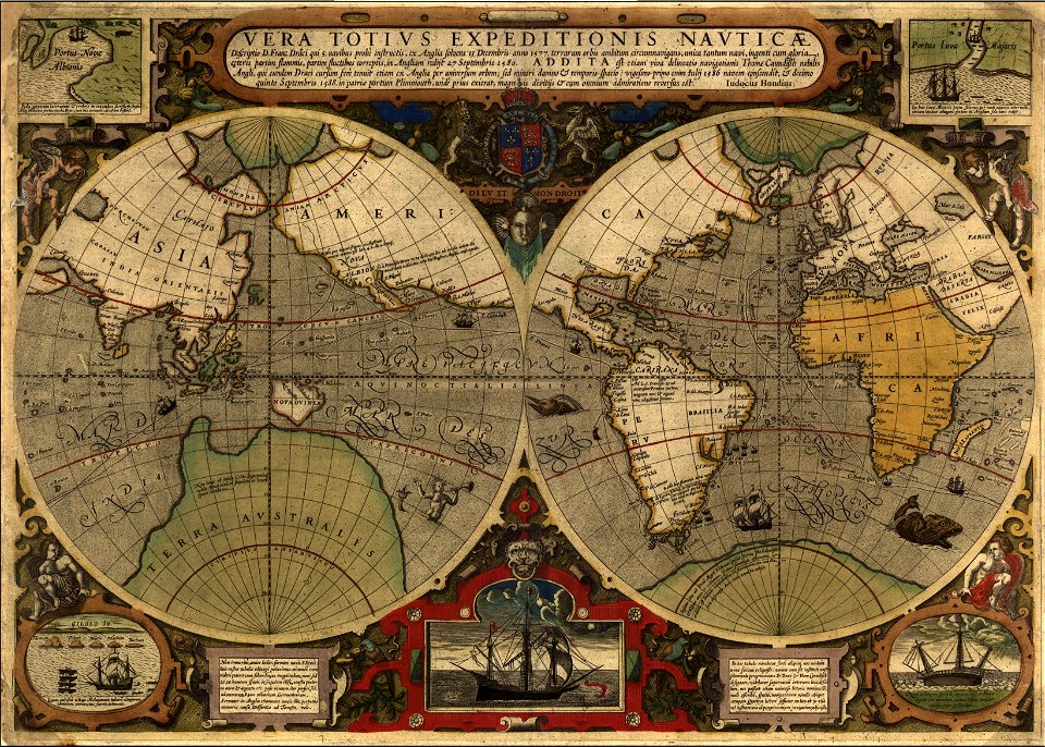
maps by jodocus hondius
1590s maps of the world
eran laor cartographic collection
willem albert bachiene
1858 van de velde maps of palestine and jerusalem
1858 van de velde maps of palestine and jerusalem
1858 van de velde maps of palestine and jerusalem
1858 van de velde maps of palestine and jerusalem
1858 van de velde maps of palestine and jerusalem
1858 van de velde maps of palestine and jerusalem
1858 van de velde maps of palestine and jerusalem
curt teich postcard archives
postcards of arizona
maps by willem and johannes blaeu
1650s maps of palestine
victor levasseur - maps of france
old maps of meurthe (department)
eran laor cartographic collection
jacques chereau
charles william meredith van de velde
belad bechara
eran laor cartographic collection
claes jansz. visscher (ii)
en rejse i rødkarenernes land
old maps of myanmar
old maps of myanmar
red karen
gemeente atlas van nederland - north brabant
maps of willemstad, north brabant
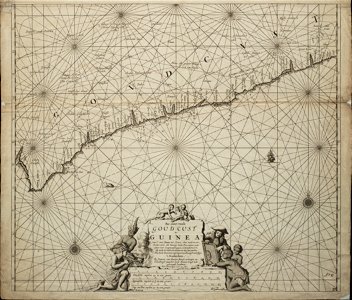
old maps of the dutch gold coast
engravings by jan luyken
atlas of the great elector
archipelagus orientalis
svg maps of fictional places or locations
maps of the land of oz
peru. incidents of travel and exploration in the land of the incas
titicaca basin
victor levasseur - maps of france
neoclassicism,romanticism
maps by guillaume sanson
maps by nicolas sanson
van de velde, 1857
gaza city in art
sanson maps of the holy land
old maps of canaan
chicago and the midwest, newberry library
old maps of the mississippi river
19th-century maps of nièvre
1852 maps of france
old maps of the holy land
1866 maps
old maps of the holy land
1866 maps
peru. incidents of travel and exploration in the land of the incas
mamacona, pachacamac
peru. incidents of travel and exploration in the land of the incas
yucay
anatomical plates and drawings of the human skull
ghosts & ghoulish scenes - skulls
eran laor cartographic collection
claes jansz. visscher (ii)
charles william meredith van de velde
al-dalhamiyya
sanson maps of the holy land
old maps of canaan
colonial wars of portugal
maps of goa by linschoten
ptolemy's second projection
emery walker
old maps of charente-maritime
maps by nicolas sanson
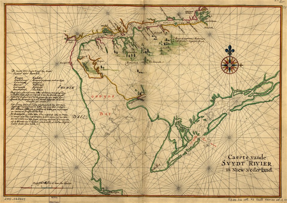
west-indische compagnie
image restoration
old submaps of paris 5e arrondissement
turgot map of paris – derivative files
atlas maior, vol 4 (netherlands) - joan blaeu, 1667 - bl 114.h(star).4
1667 maps
maps from university of amsterdam special collections
atlas der neederlanden
maps from university of amsterdam special collections
atlas der neederlanden
maps from university of amsterdam special collections
atlas der neederlanden
1770s maps of alaska
robert de vaugondy
life of christ (barberini tapestries)
old maps of the holy land
the land of the monuments (1896)
old maps of the suez canal
maps from the earth and its inhabitants, vol. xi
africa in the 1890s
victor levasseur - maps of france
1847 maps
maps by john cary
1801 maps
1710s maps of moldova
daniel de la feuille
19th century maps of landes
cartes de franz schrader
the nile boat, or glimpses of the land of egypt
1840s maps of egypt
eran laor cartographic collection
willem albert bachiene
considérations géographiques et physiques sur les nouvelles découvertes au nord de la grande mer
isla de los estados
historical images of the saint george complex in lydda
van de velde, 1857
old maps of the holy land
joan blaeu
101 - 200 of 940
Next page
/ 10